Detroit neighborhood map
You can find on this page the Detroit neighborhood map to print and to download in PDF. The Detroit districts map presents quarters, region, suburbs and surrounding area of Detroit in Michigan - USA.
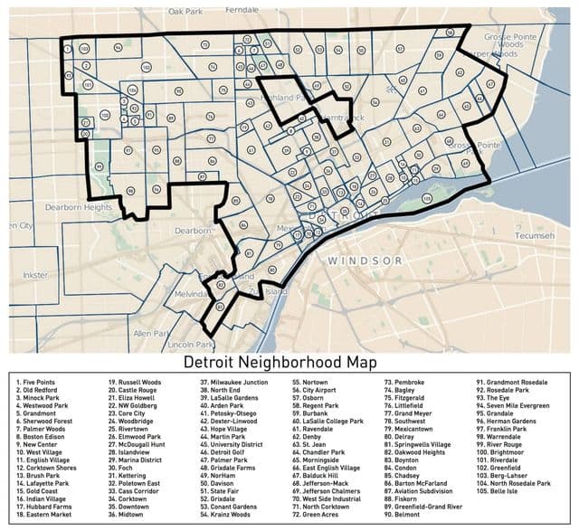
Detroit neighborhoods map
The Detroit neighborhoods map shows region and suburbs of Detroit areas. This neighborhood map of Detroit will allow you to discover quarters and surrounding area of Detroit in Michigan - USA. The Detroit quarters map is downloadable in PDF, printable and free.
Based in the New Center neighborhood and working within urban lifestyle, City Living Detroit is a full-service boutique real estate agency, working within the diverse Detroit neighborhoods, such as Lafayette Park, Boston Edison, Sherwood Forest, and more as its shown in Detroit neighborhoods map. City Living Detroit focuses on the spirit of the downtown—the growing riverfront, historic neighborhoods, and the cultural center. Corktown is the oldest neighborhood in Detroit. Some of the best bars and restaurants in the city have established themselves in the area offering a great range of options. In 2007, Downtown Detroit was recognized as a best city neighborhood in which to retire among the United States’ largest metro areas by CNN Money Magazine editors. Some of the oldest neighborhoods are along the Woodward and East Jefferson corridors.
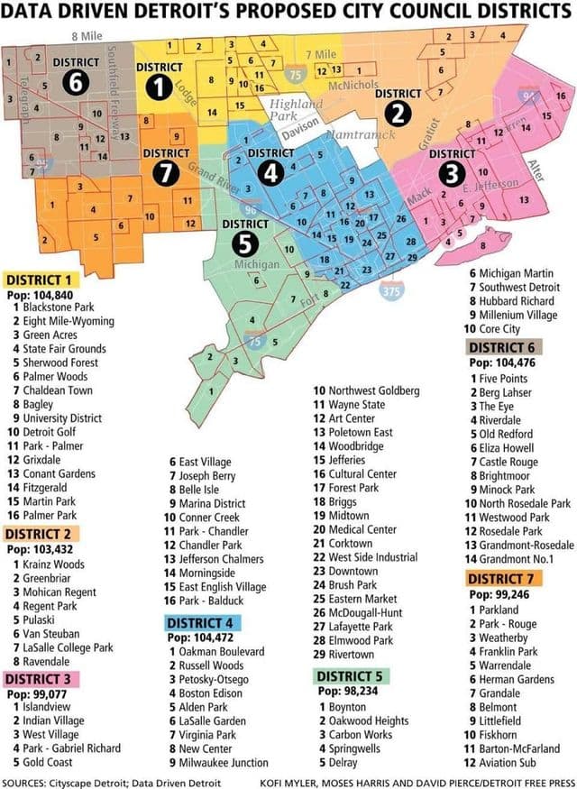
Detroit districts map
The Detroit districts map shows all quarters and suburbs of Detroit. This district map of Detroit will allow you to discover areas and the region of Detroit in Michigan - USA. The Detroit districts map is downloadable in PDF, printable and free.
District 1 hugs Detroit northwest side as its mentioned in Detroit districts map, with Grand River Avenue, one of the state oldest trading lines, as its main thoroughfare. Runs east on State Route 102 (Eight Mile) from Five Points, turns south down Route 39, east on McNichols, south on Ardmore, west on I-96, south on Evergreen, west on Fullerton, north along M-14, west on Puritan, north on Five Points back to Route 102. District 2 encompasses a wide variety of neighborhoods, from cozy bungalows to stately mansions. The resurgent Avenue of Fashion is a staple of the area. Route 102 east from Route 39, southeast along railroad tracks near Wanda to Seven Mile, west to John R. District 3 is eastside Detroit through and through. With Gratiot Avenue as one of its main streets, it is also home to City Airport. East on 102 from railroad tracks near Wanda, southwest on Kelly, west on Maddelein, south on Route 3 (Gratiot), west on McNichols, southeast on Conner, west on Harper, south on Route 3, northwest on McClellan, southwest on Harper, southeast on Crane, southwest along I-94, north on Sherwood, west on Huber, north across railroad tracks, west south of Caniff to Conant, southwest on Carpenter, northwest along I-75, west on McNichols, north on John R, east on Seven Mile, northwest along railroad tracks to 102.